Drone Support Services · Commercial Real Estate
Aerial Documentation Services for CRE
Professional drone documentation for brokers, property managers, and asset owners — delivered through a secure digital portal within 48–72 hours, weather and airspace permitting.
The CRE Property Journey
Every stage of a property's life has a right package. Find where you are — and we'll deliver what you need.


Choose Your Package
All packages are delivered through a secure private portal. Pricing shown is the base rate — contact us for a custom quote based on property size and location.
Listing Launch Package
From flyover to listing-ready in 48 hours.
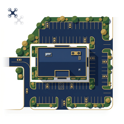
High-impact aerial imagery, video, and a 360° panoramic view — captured by a licensed FAA Part 107 operator — that helps buyers and tenants understand your property before they ever visit. Every image is composed to show visibility, parking, ingress/egress, and site positioning.
What's Included
- 10–20 curated aerial photos (color corrected)
- 15–45 second aerial video (approach + access fly-through)
- 360° panorama at primary entrance
- Private portal — all deliverables shareable from a single link, accessible for [X] months
- 48-hour delivery, weather and airspace permitting
Property Aerial Observation Report
Full-site aerial coverage before you commit to a formal assessment — at a fraction of the cost.
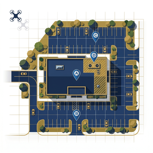
A licensed FAA Part 107 drone operator documents the complete property in a single flight — roof surfaces, building facades, parking areas, and rooftop mechanicals. Findings across all zones are organized into a professionally formatted aerial observation report with annotated imagery and items flagged for qualified contractor follow-up. Delivers documented surface coverage across the full property envelope for a fraction of the cost of a preliminary commercial site assessment.
What's Included
- Full-property orthomosaic — aerial bird's-eye overview
- Zone-by-zone coverage: Roof · Facades · Parking · Mechanical
- Annotated imagery — items flagged for qualified contractor follow-up
- Written observation summary organized by zone
- Secure portal access — shareable with partners, investors & lenders
- 72-hour delivery, weather and airspace permitting
Commonly Used For
Visual observation only — not an inspection, audit, or engineering assessment.
Priced for standard commercial sites. Contact us for larger or multi-building properties.
Request a Quote
Roof & Facade Aerial Observation Report
Every roof surface and building elevation — documented, annotated, and ready to share.
A licensed FAA Part 107 drone operator captures high-resolution orthomosaic imagery of all roof surfaces and oblique photography of every building elevation — coverage a ground-level inspection or roofing contractor cannot provide. Findings are organized into a professionally formatted aerial observation report with annotated imagery, location references, and items flagged for qualified contractor follow-up. Each report carries a unique report number and is formatted for direct use by insurance carriers, lenders, and due diligence teams.
Industry context Commercial property underwriting and loss-control workflows increasingly rely on high-resolution aerial imagery of roofs and structures to evaluate risk and condition. Our reports — orthomosaic overview plus targeted close-ups — are structured to align with how carriers and lenders actually review properties. Source: Verisk →
What's Included
- Roof orthomosaic — full aerial surface overview
- Targeted close-ups: penetrations, HVAC, drains, flashing, seams
- Four-elevation facade coverage (N · S · E · W)
- Annotated imagery — items flagged for qualified contractor follow-up
- Written observation summary + unique report number
- Secure portal access — shareable with insurers, lenders & contractors
- 72-hour delivery, weather and airspace permitting
Commonly Used For
Visual observation only — not an inspection, audit, or engineering assessment.
Property Watch Program
A growing, time-stamped aerial archive — same flight paths, same angles, every quarter.
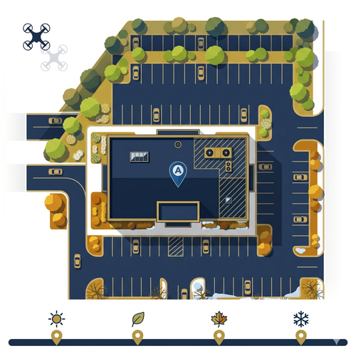
Quarterly aerial visits that build a documented visual history of your property over time — same GPS-consistent flight paths, same angles, same coordinates every visit. Every flight adds to a growing archive accessible on demand by investors, lenders, and insurance carriers without chasing files or managing permissions. In Northern California, that archive directly supports insurance renewals, lender diligence, and refinancing preparation with time-stamped visual proof of property condition across seasons.
Industry context California’s insurance regulator has documented a sharp increase in carriers using aerial imagery to inspect properties and make coverage decisions — a trend significant enough to prompt proposed legislation requiring notice and dispute rights for policyholders. An owner-controlled aerial archive puts you on equal footing. Source: California Department of Insurance →
What's Included Each Quarter
- Growing portal archive — all quarters organized and accessible on demand
- Quarterly aerial visit — GPS-consistent flight path, same coordinates every visit
- Consistent corner & elevation photo set (same angles each visit)
- Roof nadir coverage
- 10–20 image comparison set (current vs. prior quarter)
- Change log: visible differences documented each visit
Commonly Used For
Visual observation only — not an inspection, audit, or engineering assessment.
Why aerial documentation matters now
California’s Insurance Commissioner has flagged a sharp increase in carriers using aerial imagery to inspect properties and make coverage decisions — a trend significant enough to prompt proposed consumer protection legislation. That makes an owner-controlled, time-stamped aerial record more valuable than ever: when a question about your property’s condition comes up at renewal time, you have your own documentation, not just whatever a third-party flyover captured.
Read the California DOI press release →Which Package Is Right for Your Situation?
Not sure where to start? Match your situation to the right service.
You're Listing a Property
You need high-quality aerial marketing visuals — photos, video, and a 360° view — fast.
→ Listing Launch Package
You're in Due Diligence
You need full-site aerial documentation across all zones — roof, facades, parking, and mechanicals — before closing or between formal assessments.
→ Property Aerial Observation Report
You Need a Building Envelope Report
You need documented aerial coverage of your roof and all building elevations — formatted for insurance carriers, lenders, or contractor conversations.
→ Roof & Facade Aerial Observation Report
You Own or Manage a Property
You want a growing aerial archive that documents your property over time — supporting insurance renewals, lender reporting, and long-term condition records.
→ Property Watch Program
One Portal. Every Deliverable. Every Flight.
For recurring programs, the portal is more than delivery — it's the interface to a growing, flight-path-consistent aerial archive tied to your property. Every flight adds to that record, accessible on demand by investors, lenders, and insurance carriers. No other documentation method builds that longitudinal view from the same angles, at the same coordinates, visit after visit.
For one-time projects, your deliverables — photos, video, and observation reports — are organized and shareable from a single link, accessible from any device by the contractors, agents, and partners you choose.
View a Sample Portal →Ready to Get Started?
Tell us about your property and we'll recommend the right package and provide a quote — usually within one business day.
Request a Quote